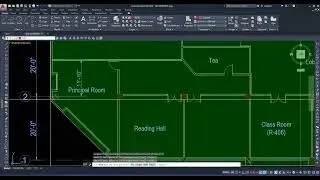
FINDING AREA IN AUTOCAD IN DIFFERENT WAY
Calculates the area and perimeter of objects or of defined areas.
You can obtain measurements by selecting an object, or by specifying points to define what you want to measure. The area and perimeter of the specified object are displayed at the Command prompt and in the tooltip.
The MEASUREGEOM command provides additional measurement options. You can also use BOUNDARY to create a closed polyline or region and then use LIST or the Properties palette to find the area.
The following prompts are displayed.
Specify first corner point
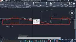
Calculates the area and perimeter defined by specified points. Start by specifying the first point. All points must lie in a plane parallel to the XY plane of the current user coordinate system (UCS).
Specify next point
A rubber band line from the first specified point to the cursor is displayed. Continue to specify points to define a polygon and then press Enter to complete the definition of the perimeter. The area to be calculated is highlighted in green.
If you do not close the polygon, the area is calculated as if a line were drawn from the last point entered to the first. When the perimeter is calculated, that line length is added.
Object
Calculates the area and perimeter of a selected object.
Select objects
Select objects such as circles, ellipses, splines, polylines, polygons, regions, and 3D solids.
If you select an open polyline, the area is calculated as if a line were drawn from the last point entered to the first. When the perimeter is calculated that line length is ignored.
The centerline of a wide polyline is used to make area and perimeter (or length) calculations.
Add area
Turns on Add mode and displays the total cumulative measurements of subsequent areas that you specify. You can pick points and select objects to obtain the calculation. For example, you can select two objects to obtain a total area.
If you pick points and do not close the polygon, the area is calculated as if a line were drawn from the last point entered to the first.
Subtract area
Subtracts areas and perimeters from a total area. You can pick points or select objects to obtain the calculation. In the following example, the second selected object is subtracted from the first.
You can use LIST to display and then copy the properties of selected objects to a text file.
The text window displays the object type, object layer, and the X,Y,Z position relative to the current user coordinate system (UCS) and whether the object is in model space or paper space.
LIST also reports the following information:
Color, linetype, lineweight, and transparency information, if these properties are not set to BYLAYER.
The thickness of an object, if it is nonzero.
Elevation (Z coordinate information).
Extrusion direction (UCS coordinates), if the extrusion direction differs from the Z axis (0,0,1) of the current UCS.
Additional information related to the specific object type. For example, for dimensional constraint objects, LIST displays the constraint type (annotation or dynamic), reference type (yes or no), name, expression, and value.