Geospatial Python class to extract vertices inside a polygon - Tutorial
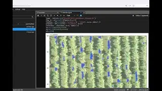
We have to redefine the way we do our geospatial analysis. It is not enough to know the "tool" but to master the "process" if we want to provide spatial solutions for the always bigger geospatial data available. We have done a simple process of extracting vertices from polygons, lines and points inside a polygon in Python, but not a simple and declarative script but as a Python class.
Input data
You can download the input data from this link:
https://hatarilabs.com/ih-en/geospati...


![[ No Copyright ] La MEJOR MÚSICA CHILL OUT Ambiental | Cozy Fall](https://images.mixrolikus.cc/video/-KIsXHMC1JQ)