How to georeference a image/raster with Python and Rasterio - Tutorial
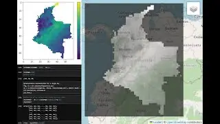
Georeferencing in Python has the advantage that it can be performed repeatedly without the need to define control points each time. It also allows you to add/remove control points and observe the impact on the transformation array. This tutorial demonstrates the complete georeferencing process of a national map using 3 points whose pixel coordinates have been extracted from the Paint utility in Windows. The tutorial also exports the raster while assigning a reference system.
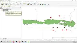
Input data
You can download the input data from this link:
https://hatarilabs.com/ih-en/how-to-g...


![[ No Copyright ] La MEJOR MÚSICA CHILL OUT Ambiental | Cozy Fall](https://images.mixrolikus.cc/video/-KIsXHMC1JQ)