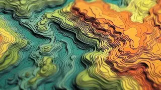
One Minute Map Hack: Emboss Basemap Imagery
Here's how you can create a tactile and (I think) fun sense of depth for an imagery basemap using blend modes and effects in ArcGIS Online.
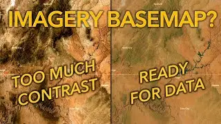
0:00 Start out with the World Imagery basemap. Give it a Brightness and Contrast effect of 196 and 96, respectively. And respectfully.
0:14 Via the layers, add the World Imagery again, from Living Atlas.
0:22 Also add a Living Atlas layer named Bathymetry Light.
0:28 Group the Bathymetry and Imagery layers, with Bathymetry on top.
0:35 Apply a Destination Out blend mode to the Bathymetry layer. This is effectively a clipping mask, so only the imagery’s land areas are visible in the group.
0:42 With the whole group selected, apply a black Drop Shadow effect.
0:49 Back in the group, select the bathymetry layer, and give it a Drop Shadow effect of white. This gives the land a bright edge.
1:00 Profit.
Here's a link to mine: https://www.arcgis.com/apps/mapviewer...
Check out some other social channels where I share how-to's and updates on random map adventures:
http://adventuresinmapping.com
https://www.esri.com/arcgis-blog/auth...
/ john_m_nelson
/ johnmnelson
/ johnmnelson


![[FREE] Hard Trap Type Beat 2021](https://images.mixrolikus.cc/video/tmPvUw6c2AE)