How to upload Shapefiles to PostGIS with Python, Geopandas and SQLAlchemy - Tutorial
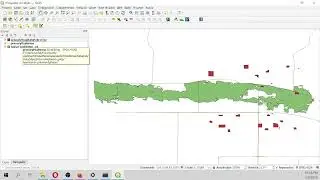
In our research for new geospatial tools in Python and better ways to deal with geospatial data we found that complex or full featured processes are already included in the common spatial libraries as Geopandas. We have developed an applied example to upload point / line / polygon ESRI Shapefile to a Postgres / Postgis database with Python, Geopandas and SQL Alchemy in a few lines of code. Besides, we have simplified the procedure to run a Postgres database inside the Hakuchik Docker image fully connected to QGIS.
More info:
https://www.hatarilabs.com/ih-en/how-...


![[ No Copyright ] La MEJOR MÚSICA CHILL OUT Ambiental | Cozy Fall](https://images.mixrolikus.cc/video/-KIsXHMC1JQ)