Convex Hull | XTools Pro, extension for ArcGIS Desktop
In this video you will see a practical example of using the XTools Pro's “Convex Hull” tool. XTools Pro provides more than 80 vector spatial analysis, shape conversion and table management tools and features for fast and effective work in ArcGIS Desktop.
Download XTools Pro
http://bit.ly/2dM5hKX
Try it free for 14 days
http://bit.ly/2cRUJZ8
XTools Pro is one of the most popular extensions for ArcGIS Desktop end users.
In this video, we will demonstrate a practical example of using the XTools Pro "Convex Hull" tool.
We are going to work with the data obtained from sensors used to monitor bears in the “Wood-Tikchik State Park” in Alaska. All bears in this park are equipped with GPS-receivers. Bears movement observation data is gathered in a point dataset. In our example, we will model the natural habitats of bears within the park area using the XTools Pro Convex Hull tool. Here is how.
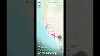
First, we will create a natural habitat polygon for all bears in the park. For that, we select the bears point layer in the table of contents and run the Convex Hull tool from the XTools Pro toolbar menu.
Input features have been automatically selected in the tool dialog. We will leave the default output dataset name and location. So, we will only specify the buffer size value for the convex hull. We are going to add the buffer for the hull as these sensors are known to have 500 feet tolerance.
Running the tool to build the convex hull.
As we can see, the output hull is too rough. So, we are going to build another one with a higher level of detail which is possible with the Convex Hull tool in XTools Pro.
We are leaving the same parameters but specifying the 40% for the level of detail this time.
This way we can get a hull with more appealing shape.
Then we are going to build natural habitat polygons for each bear. We are running the Convex Hull tool again, this time specifying “SensorID” with IDs of each sensor as a Group By field and leaving 40% for the level of detail and 500 feet for buffers.
Now we’ve got all needed bear natural habitats in the park, one for all bears and separate habitat polygons for each bear.
Let’s zoom closer to make sure the buffer zones are correctly applied to the hulls. As we can see, all the hulls are built with buffers in order to take into account sensors accuracy.
Finally, we finish up modeling the natural habitats color coding and labeling them with sensor IDs.
XTools Pro is the #1 Productivity Suite for ArcGIS Professionals.
Visit our website to learn more and try XTools Pro free for 14 days.