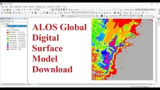
ALOS Global Digital Surface Model Download
ALOS Global Digital Surface Model Download (30 m Resolution)
Download: https://www.eorc.jaxa.jp/ALOS/en/aw3d...
Digital Surface Model (DSM/DEM)
ALOS Global Digital Surface Model Download (30 m Resolution)
Download: https://www.eorc.jaxa.jp/ALOS/en/aw3d...
Digital Surface Model (DSM/DEM)