Principal Component Analysis (PCA) of Satellite Image in Envi
Principal Component Analysis (PCA) of Satellite Image in Envi
How to Download Landsat satellite image / Earth explorer/ USGS = • How to Download Landsat satellite ima...
Create and Edit Shapefiles = • How to Create and Edit Shapefiles in ...
How to do Dissolve / Union / Intersect / Merge in Arc GIS (Geo processing) = • How to do Dissolve / Union / Intersec...
Mosaic Raster data sets in Arc GIS/ Merge Raster Data sets In Arc GIS = • Mosaic Raster data sets in Arc GIS/ M...
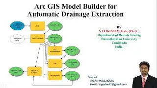
Drainage Extraction in Arc GIS using Digital Elevation Model (DEM)/ Automatic Drainage Extraction = • Drainage Extraction in Arc GIS using ...
Importing Excel Data in Arc GIS/ How to Do interpolation (IDW) in Arc GIS = • Importing Excel Data in Arc GIS/ How ...
How to create Slope, Contour, Aspect and Hillshade in Arc GIS using Digital Elevation Model (DEM) = • How to create Slope, Contour, Aspect ...
Projection of Raster and Vector files in Arc GIS (Spatial Referencing) = • Projection of Raster and Vector files...
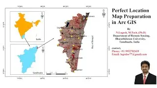
Layout preparation in Arc GIS and exporting in JPEG = • Layout preparation in Arc GIS and exp...