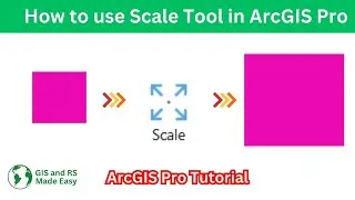
Scale Tool in ArcGIS Pro | ArcGIS Pro Beginners' Tutorial
#arcgispro #tutorial #arcgis #gis
How to use scale tool in ArcGIS Pro | ArcGIS Pro Tutorial for Beginners
Welcome back to GIS & RS Made Easy! In this tutorial, we're going to get into one of the fundamental tools of ArcGIS Pro: the Scale Tool. Whether you're a GIS novice or a seasoned pro, mastering this tool is essential for precision mapping and analysis.
In this video, we'll walk you through the ins and outs of the Scale Tool, exploring its functionality and practical applications. You'll learn how to leverage the power of scaling to enhance your GIS projects.
Here's what you can expect to learn:
Understanding the basics of the Scale Tool interface in ArcGIS Pro.Resizing features and layers with precision using various scale methods.
Tips and tricks for efficient scaling workflows to streamline your GIS projects.Real-world examples and demonstrations to illustrate the practical applications of the Scale Tool.Whether you're working on spatial analysis, cartography, or data visualization, mastering the Scale Tool will elevate your GIS skills to the next level. Join us on GIS & RS Made Easy as we unlock the full potential of ArcGIS Pro's Scale Tool. Don't forget to like, share, and subscribe for more tutorials on simplifying GIS and remote sensing!
Search Terms:
ArcGIS Pro, Scale Tool in ArcGIS Pro, GIS tutorials, GIS mapping, Geospatial analysis, Cartography tips, Spatial data manipulation, ArcGIS Pro tips and tricks, Remote sensing, Geographic information systems, Scale transformation, GIS scaling techniques, Spatial accuracy, GIS software tutorials


![[FREE] Hard Trap Type Beat 2021](https://images.mixrolikus.cc/video/tmPvUw6c2AE)