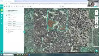
Loading Sentinel-2 data into Google Earth Engine
Getting started with using GEE for analysing earth observation data doesn't have to be painful! In this video I'll show you how to load and visualise Sentinel-2 data based on date, location, and cloud coverage. This is a follow on from my video showing how to load Landsat data - see • Loading Landsat 8 data into Google Earth E...
The code that I'm using in the video is below
// Let’s define the image collection we are working with by writing this command.
// We are creating a new variable 'image' that will come from the L8 collection we have imported
var image = ee.Image(S2
// We will then include a filter to get only images in the date range we are interested in
.filterDate("2019-07-01", "2021-10-30")
// Next we include a geographic filter to narrow the search to images at the location of our ROI point
.filterBounds(ROI)
// Next we will also sort the collection by a metadata property, in our case cloud cover is a very useful one
.sort("CLOUD_COVERAGE_ASSESSMENT")
// Now lets select the first image out of this collection - i.e. the most cloud free image in the date range
.first());
// And let's print the image to the console.
print("A Sentinel scene:", image);
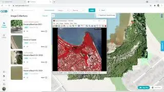
// Define visualization parameters in a JavaScript dictionary for true colour rendering.
// Bands 4,3, and 2 are needed for RGB (true colour composite).
var trueColour = {
bands: ["B4", "B3", "B2"],
min: 0,
max: 3000
};
// Define visualization parameters in a JavaScript dictionary for true colour rendering.
// Bands 8,4,3 are needed for RGB (false colour composite).
var falseColour = {
bands: ["B8", "B4", "B3"],
min: 0,
max: 3000
};
// Centre the scene to the ROI
Map.centerObject(ROI, 12);
// Add the image to the map, using the visualization parameters.
Map.addLayer(image, trueColour, "true-colour image");
// Add the image to the map, using the visualization parameters.
Map.addLayer(image, falseColour, "false-colour image");