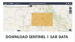
Layerstacking of landsat images in arcgis
In this tutorial, i will present how to layerstack landsat images in arcgis
Layer stacking is a process for combining multiple images into a single image. In order to do that the images should have the same extent (number of rows and number of columns), which means you will need to resample other bands which have different spatial resolution to the target resolution. In other words, all images/bands should have same spatial resolution to be able to perform layer stacking.
However, combining images/bands will increase the final stacked image size, and consequently will increase the processing time later when you do your analysis. If you know that you will not use all the images/bands in your analysis, then it will be better to not stack all the images into a single image, and choose only specific images of interest. It depends on the purpose/objectives of your study
#gis
#arcgis
#arcmap
#arcgistutorial
#layerstack
#landsat
#remotesensing
![EF Wither Storm Add-on ,Survival [MCPE-MCBE]Wither Storm In Minecraft,EnderFoxBoy MC🦊!!!](https://images.mixrolikus.cc/video/3c6eTmnbms4)


![Cesqeaux & Tisoki - Give It To Me [NCS Release] Music provided by NoCopyrightSounds](https://images.mixrolikus.cc/video/z4QRXyMTZQs)