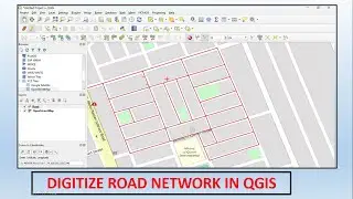
Watershed Delineation using Arc Hydro Tool Bar in arcGIS | How to create Drainage Map
#Watershed analysis refers to the process of using #DEM and #raster data operations to delineate watersheds and to derive features such as streams, stream network, catchment areas, #basin etc.
Watershed analysis is used for the management and planning of natural resources.
1.To provide necessary inputs for hydrological modeling.
2.Flood prediction modeling and snow melt runoff models etc.
3.Watershed analysis provides catchment boundaries but also hydrological parameters useful for management programs.