Southeast Wisconsin weather: Warm today, taste of fall this weekend
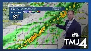
Overnight lows have fallen into the 50s across southeast Wisconsin. However, more humidity has built in over the last several hours. Sunshine will break out this morning, but more clouds enter in from the northwest as a cold front approaches. Before the front arrives, highs climb into the 80s. Scattered showers and a few thunderstorms are possible as the front moves by. Rain enters into southeast Wisconsin late this afternoon and into the evening hours.
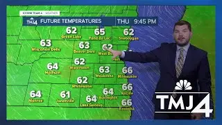
After the front passes, winds turn northerly and a cool down begins. Spotty showers will be possible through Saturday afternoon. Lows drop into the mid and upper 50s tonight. Friday's high temperatures may only top out in the upper 60s and lower 70s.
By Saturday morning, inland areas could drop into the lower 40s - with lows near 50 at the lakefront. Cooler conditions persist through Sunday before warm air moves back in next week.
Read more here: https://www.tmj4.com/weather/forecast...
________________
TMJ4 News in Milwaukee, Wisconsin is your source for local breaking news, in-depth investigations, the latest weather and traffic, and livestreams on news happening right now.
Subscribe to the TMJ4 YouTube channel: / @tmj4
Watch 24/7 TMJ4 live coverage here: https://www.tmj4.com/live
Download the TMJ4 app: https://www.tmj4.com/apps
Sign up for the TMJ4 Newsletter: https://www.tmj4.com/newsletters
Watch more TMJ4 on YouTube: / @tmj4
On The Go with James Groh: https://on.tmj4.com/3V1oLvH
Milwaukee Tonight: https://on.tmj4.com/3UZroya