How To Create Open Channel Design, | Profile,Alignment,Drainage | in Autodesk Civil 3D.
Canal design in AutoCAD Civil 3D involves several steps that are important to create an efficient drainage system. Here is a general process for canal design in AutoCAD Civil 3D:
Collect Data: Gather information about the study area including existing land use, topography, and hydrology.
Create a Surface: Use the collected data to create a surface model of the area. A surface model is a 3D representation of the ground surface and its features.
Determine the Drainage Area: Determine the drainage area by analyzing the surface model. This involves identifying the locations of high and low points and calculating the flow direction of water.
Determine the Design Flow: Calculate the design flow based on the expected maximum amount of water that the canal will need to handle.
Define the Canal Alignment: Define the canal alignment by creating a centerline that follows the desired path. The alignment should take into account the terrain and any existing obstacles or features.
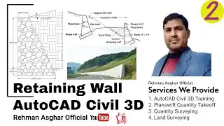
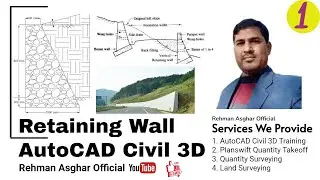
Define the Canal Cross Section: Create a cross-sectional profile of the canal at regular intervals along the alignment. This will determine the canal's depth, width, and slope.
Design Canal Structures: Design canal structures such as weirs, culverts, and spillways that will be needed to manage water flow.
Create a Grading Plan: Create a grading plan that includes the canal and surrounding areas. This plan will show how the earth should be reshaped to accommodate the canal.
Create Construction Drawings: Create construction drawings that provide detailed information about the design, including dimensions, materials, and specifications.
Review and Revise: Review the design and make revisions as necessary to ensure that it meets the requirements of the project.
AutoCAD Civil 3D provides a range of tools that simplify these steps and allow designers to create precise and efficient canal designs.
Working Files( https://bit.ly/3JfGWth)
Do not forget to subscribe!
GET IN TOUCH
Contact us on: [email protected]
FOLLOW US ON SOCIAL
Get updates or reach out to Get updates on our Social Media Profiles!
Facebook: / rehmanasgharofficial
Instagram: / raofficials_yt
Twitter: / raofficial_ytub
WhatsApp Us: +92-333-689-5267
#rehmanasgharofficial #civilengineering #civil 3d #canal design in AutoCAD civil 3d #autodesk civil 3d #civil 3d in Urdu #design profile in civil 3d #civil 3d channel design #create canal alignments in civil 3d #open channel design civil 3d #open channel design using civil 3d #water channel design #civil 3d tutorial for canal design #civil engineer, how to calculate quantities in civil 3d, #civil 3d tutorial in Hindi, #Canal Cross Section in Civil 3D, #Canal Typical Cross Section in Civil 3D,#Rehman Asghar Official,
#AutoCAD civil 3d,
#AutoCAD,
#civil 3d,
#civil 3d parcels creation
#how to create parcels in AutoCAD civil 3d,
#parcel auto numbering in AutoCAD,
#parcel creation tools civil 3d,
#Civil engineering,
#civil 3d parcels tutorial,
#creating parcels from objects in AutoCAD civil,
#parcel in civil3d,autocad civil 3d in Urdu,
#AutoCAD civil 3d in Hindi,
#parcel in civil 3d,
#parcel labels civil 3d,
#parcel labels in civil 3d,
#AutoCAD civil 3d tutorials in Urdu/Hindi,
#civil 3d parcel table
#points,
#alignments
#profiles
#points groups
#alignments Labes
#alignment Table
#Road Cross Sections
#Cross Section Volume Calculation
#civil
#canal Alignments
#Canal Profile
#Canal Cross Sections
#autodesk
#Creat Road Alignments
#Cross Sections from Elevation and Distance
#Pipe Network
#Sewer Pipe network
#Presure Pipe Network
#Survey Data Process
#Survey Data Manipulation
#Survey Data sets
#Traverse
#Open Traverse Calculation
#Close Traverse Calculation
#Traverse Report in Excel