26 GIS 3D Contours and Automatic Contours from Geo
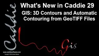
GIS: 3D Contours and Automatic Contouring from GeoTIFF Files
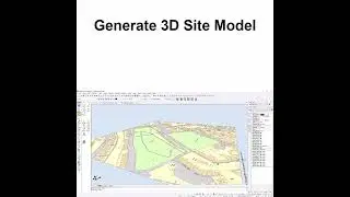
Creating GIS Data sources from ArcGIS data with automated read of 3D contour height, and conversion of GeoTIFF file to Contour Shape file with specified contour spacing for use as 3D GIS data source
Visit the Caddie website at https://www.caddiesoftware.com
Download your Evaluation copy of Caddie:
https://www.caddiesoftware.com/downlo...
Contact Us:
International: +44 (0)1234 834 920 (Head Office)
South Africa: +27 (0) 12 644 0300
You can access the online training options from the 'Help' menu within Caddie or Open Online Training Exercise Files.
For more information on our classroom and online training options go to https://www.caddiesoftware.com/services
Visit the Caddie Quickstart Web Page
Visit the Caddie YouTube Channel