Insight 1: How to Identify Fields with Domains in a Geodatabase
In a geodatabase used widely in GIS with tools like Esri's ArcGIS domains are rules that restrict the values that can be entered into attribute fields. These rules improve data quality by limiting inputs to either coded value domains—a predefined list of valid options or range domains, which define allowable numeric ranges. Identifying which fields are associated with these domains is essential for data validation, schema quality control, and automation workflows.
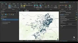
In this video, we'll walk through several methods using both the ArcGIS interface and Python scripting with ArcPy to quickly and accurately identify which fields in your geodatabase are using domains.
To show you how to identify fields with domains in a geodatabase, we'll be using three powerful tools, each suited for different workflows and levels of detail.
Tool 1: X-Ray for ArcCatalog
https://www.arcgis.com/home/item.html...
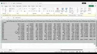
X-Ray is an Excel-based add-in for ArcCatalog that allows you to explore geodatabase schema in a highly visual format. With it, you can export a feature dataset’s metadata, including domain assignments for each field, into a spreadsheet. This is perfect for documentation and bulk review.
Tool 2: Geodatabase Diagrammer
https://github.com/nicogis/Geodatabas...
This Visio-based utility lets you generate ER-style diagrams of your geodatabase schema. You can easily spot which fields are using domains by checking field properties in the diagram. It’s ideal for presentations and understanding relationships at a glance.
Tool 3: ArcPy Scripting
Finally, we’ll use a simple Python script with ArcPy to programmatically list all fields in a feature class or table that have domains assigned. This method is fast, reproducible, and easily integrates into automation pipelines.