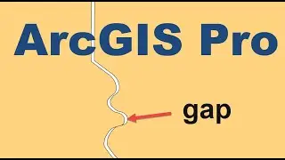
Remove polygon gaps and overlaps with Integrate
If your polygon dataset has somehow developed small gaps and overlaps when there should be a perfectly aligned boundary, the ArcGIS Pro Integrate tool can be used to fix these misalignments. This video goes through how to use, how it works and when the tool might not be appropriate.
LinkedIn - / spatialmonkey
Facebook - / spatialmonkey
Instagram - / spatialmonkey.sg
If you are looking to turn your georeferenced maps into GIS layers take a look at Color Scan, an extension for ArcGIS Pro and ArcMap. Download a 30-day free trial here: https://www.spatialmonkey.com/trial/
![[Raw, Boring] Four Random Landings](https://images.mixrolikus.cc/video/wacFCUJeWzc)